The Flint Riverfront Restoration Plan provides a vision that will transform the Flint Riverfront from a neglected resource into a healthy and vibrant community asset. Long isolated, this vision will enable a strong physical relationship between the Flint River and the built environment that surrounds it. Released in 2010, the plan draws on many previous studies, including “Reimagining Chevy in the Hole” (2007) and the University of Michigan-Flint Campus Master Plan (2003). The transformation envisioned in the Flint Riverfront Restoration Plan hinges on three key initiatives along the Flint River: removing Hamilton Dam and Fabri Dam, improving Riverbank Park, and repurposing Chevy in the Hole.
HAMILTON DAM & FABRI DAM
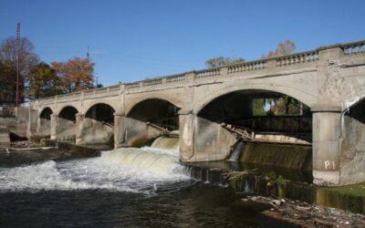
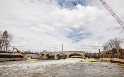
Constructed in 1920, Hamilton Dam has a long history of service to the city of Flint. The dam facilitated milling operations for the region’s logging industry and served as a water source for local industries. Throughout its life, the dam helped regulate the flow of water in the Flint River. In the 1960’s, the dam served as the upstream anchor point for a U.S. Army Corps of Engineers’ Flood Control Project. Over time, the dam devolved into a community hazard. It was classified as a High Hazard Critical Dam by the Michigan Department of Natural Resources and Environment (MDNRE). Numerous studies were completed to evaluate the dam’s structural integrity. The results of the studies were consistent, found the dam to be in poor condition, and identified substantial structural deficiencies for both the dam and its gates. The dam is recognized as the current upstream obstacle to walleye spawning and is a limiting factor in the MDNRE’s Saginaw Bay Walleye Restoration Plan, which is the MDNR blueprint for walleye population recovery in the Saginaw Bay. Ultimately, the MDNRE mandated that the Hamilton Dam be replaced.
Fabri Dam was built downstream of Hamilton Dam in 1979. Fabri Dam was an inflatable dam, designed for visual and recreational enhancement of the downtown area, associated with the Riverbank Park improvements. It offered virtually no storage capacity. Additionally, Fabri Dam also impeded fish passage and recreational navigability.
The Flint Riverfront Restoration Plan recommends restoring the Flint River by replacing both Hamilton Dam and Fabri Dam with a new in-river structure that will greatly improve access to and from the Flint River, fish and aquatic habitat, hydrology, connectivity, material recruitment and movement, geomorphology and the water quality of the Flint River.

RIVERBANK PARK
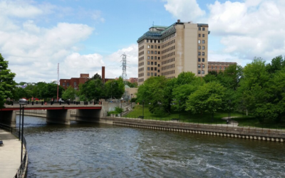
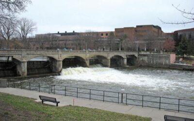
Riverbank Park is located in downtown Flint on the banks of the Flint River and is a critical part of the Flint Riverfront Restoration Project. Completed in early 1980’s, Riverbank Park was designed by landscape architect Lawrence Halprin. The intricate and complex design scheme created a series of five separate block parks that included market stalls, an amphitheater, a grand fountain, and other water-based site features. The park also featured an Archimedes’ screw that drew water from the river into the park’s system of canals, fountains, and waterfalls. This intricate design created long-term challenges, including challenges for public safety and maintenance. For decades, the park has suffered from these challenges, deteriorating conditions, and a lack of use.
The Flint Riverfront Restoration Plan envisions an improved waterfront at Riverbank Park, transformed by enhanced physical and visual access to the river. Restoration efforts will address longstanding obstacles presented by the existing park infrastructure to safety, accessibility, and maintenance. Design recommendations include creating new access points to the Flint River, constructing ADA accessible pathways, installing a new lighting network, restoring the fountains at both Grand Fountain Block and Waterwall Block, and restoring the public restroom.

CHEVY COMMONS
Chevy Commons is a large, 60+ acre site located on the Flint River, a few blocks from downtown Flint. Formerly “Chevy in the Hole,” the site contained a manufacturing complex that was established in the 1930’s as one of General Motors’ four major production facilities in Flint. Chevy in the Hole once contained 17 buildings and, at its peak, the complex employed around 8,000 workers. Plant closings and building demolitions started in the mid 1990s and continued through 2004. After demolition activities were completed, most of the site was paved with asphalt to minimize the movement of residual contamination.
The Flint Riverfront Restoration Plan, drawing on previous studies and plans, presents a vision for Chevy Commons, repurposed as a community amenity. This vision seeks to convert a vacant industrial span into a safe public open space. In pursuit of this vision, the Flint Riverfront Restoration Plan contains an array of design strategies, many of which proved to be unsuitable for the site due the nature of contamination that was subsequently determined. Nevertheless, the overarching vision from the Flint Riverfront Restoration Plan and its core design strategies are still applicable to Chevy Commons today. Core design strategies include passive, low-maintenance plantings; new, active pathways for pedestrian and non-motorized use; ecologically beneficial installations; and new connection between the adjacent neighborhoods and institutions.